Category Archives: Transport

The life of the 300

R-NET can’t seem to decide where their buses go. Over the last six/seven months, I’ve seen the destination on a certain route’s destination boards change no less than four times, even though the line still goes to exactly the same place.

When I first moved to Haarlem, the line 300 service was advertised on the front of R-NET’s buses as heading to:

Amsterdam-Z.O. via Schiphol

“Z.O.” stands for “Zuidoost”, and Amsterdam-Zuidoost is one of the city’s stadsdelen (≈ boroughs). Once you know this, this destination wording becomes clear and unambiguous: exactly what one’s looking for on the front of a bus.

A couple of months later, however, the boards were changed to read:

Amsterdam-Z.O. via Airport

True: there is only really one airport in the region and that’s Schiphol. But I would assume that most passengers travelling to catch a flight or pick someone up from an airport would know the name of the airport their flight is due to land or take off at. But alright, “Amsterdam-Z.O. via Airport” is still clear enough.

But the destination board changed again around the beginning of June to:

Amsterdam via Airport

which is pretty much false advertising! Line 300’s terminus at Amsterdam Bijlmer Arena is 8 km south of Amsterdam Centraal. I don’t think you’d be very pleased if you went to visit central London for the day and found that your bus actually terminated in Seven Sisters. Buses to Amsterdam’s Marnixstraat bus station say “Amsterdam Marnixstraat” for this reason too, so I don’t see why R-NET should be any different.

I saw today that this has been changed once more to:

Bijlmer Arena via Airport/Plaza

We’re getting close to what we started with now but at least “Amsterdam” has been corrected. As a matter of fact, the central bus station at Schiphol airport is officially referred to as “Plaza/NS” or “Schiphol Plaza/NS” – NS being a reference to the NS station under the airport; so no doubt R-NET will be changing the front of their buses again in the near future.

Landslide forced cars onto railway(!)

A section of the A890 in Scotland was damaged following landslides last year. This prompted the closure of the road and, until January, a diversion of up to 230 km around the closed section. Highland Council laided on ferries across the Loch Carron, avoiding the detour via Inverness.

The Kyle of Lochalsh Line runs alongside the section of closed road; and a rubber surface was laid between and around the single track railway so that traffic could be diverted up onto the railway and flow once again. The section of railway in question couldn’t have been longer than about 100 m but it’s still rare to find this sort of coöperation between highways and rail organisations in the UK.

This is a little old but I thought it was still worth a mention. The road in question has since reöpened, but I found this video on YouTube (skip to 8 minutes in) which shows the arrangement in pretty good detail.

Door sein- en wisselstoring

There was a failure at the ‘traffic control centre’ in Amsterdam this morning. It took me almost four hours to get to work; and being stranded at Utrecht Centraal (34 km south of my workplace) for a good forty minutes and sitting in traffic on the replacement bus from Naarden-Bussum didn’t help either.

The entire rail network of the Netherlands is, according to Wikipedia, controlled from just thirteen control centres. Closing small signalboxes because they’re cute and you want to be evil is all well and good but the effects if something goes wrong spread like wildfire.

Platform numberwang

When I started writing this particular post, the answers which I later discovered weren’t that obvious but I feel quite dumb for not seeing it sooner. I do do quite a bit of research for this blog’s posts but it really depends if the subject is something I can really get into—something closer to my heart, I know enough (e.g. specialist terms) to be able to search deeper and in more detail.

I’d first like to clarify something: I’m not a trainspotter. I’d also like to clarify that I don’t hate trainspotters and apologies for offending any of them fellow human beings by suggesting that it’s beyond acceptable to be interested in such things. We all have hobbies, and we have hobbies that other people either don’t understand or are disinterested in. I am however quite keen on the railways themselves: not so much the signalling and stations, but the tracks and how they all fit together are what interest me most. I’ve been drawing sketches of track diagrams for what, ten years now—just as doodles—and I’ve thought a couple of times of scanning them all in and seeing if they fit together in some way. This isn’t quite the same as when, as a child, I’d draw large town plans on A4 paper and deliberately ‘expand’ the town or village onto another page. There were ferry crossings (easy to draw) and really idiotically complex junctions, but never any houses for some reason; and I always stuck car parks underground (too much effort to draw them on the surface).

To cut a long story short, things on the railways like the stations don’t usually interest me—fine architecture: yeah, sure but everyone enjoys the sight of a nicely built 19th-century station every now and then(!)—but there is something which has been catching my attention since I moved to Haarlem, the provincial capital of Noord-Holland. I take the train to work and pass through a few stations with, quite frankly, odd platform numbering schemes. At this point, you may leave if you want to. Haarlem itself doesn’t have platforms numbered 2 or 7; Amsterdam Sloterdijk begins numbering platforms at number 3; Amsterdam Muiderpoort has a set of platforms—2 and 3—on one side of the station but another set—platforms numbered 8 and 9—on the other.

Now this is all pretty trivial but I found it pretty strange that some stations didn’t have certain platforms. Or more correctly, platform numbers. And that’s when I started to feel pretty dumb.

In the United Kingdom, we would use the word ‘platform’—a train stops at a platform, you board a train from a platform, and it’s "platform 1 for the …". The Dutch word used, however, is ‘spoor‘ which translates as ‘track’. There is a word for ‘platform’ but this refers more to the physical object itself: ‘perron‘. It’s just that the Dutch noticed that a train could be at more than one platform, in principle, but only ever on one set of tracks. I think; I’m not sure which country has the better system.

But there is indeed a track between the ‘platform 1’ track and the ‘platform 3’ track at Haarlem, called ‘spoor 2’. It’s used by trains to bypass platforms 1 and 3, which makes sense, but it doesn’t have a platform of its own—think of a sandwich with three cheese slices: the bread is/are platforms, and each cheese slice is a different track. But what’s more interesting is why I’m asking you to imagine a cheese-and-platform sandwich.

Amsterdam Muiderpoort also now makes sense: from west to east, the first viaduct to be built supports tracks 1–6 including platforms serving tracks 2 and 3. When the line down to Utrecht was built later on, its viaduct carried tracks 7, 8 and 9 and platforms serving tracks 8 and 9; track 7, I believe, has been lifted but the tracks are still numbered in sequence. Amsterdam Sloterdijk does have two tracks to the north of the track serving platform 3 that I guess could be considered part of the station’s area, but not part of the station; I think they’re only used by freight traffic but they could well be numbered as tracks 1 and 2. Will investigate.

And just for trivia’s sake: Nijmegen has the highest numbered platform in the country, platform 35; pretty good going considering Nijmegen only has four platforms in total.
Getting to Christmas

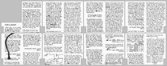
Below is a composite image of notes I made on Saturday evening on how I’m going to be getting to my grandparents for Christmas. Every year for the past nineteen—except last year and also in 2001 or 2002, though I can’t remember which one of those—me and my family have descended upon Bournemouth for the Christmas holiday. This year will be the first in which I’ll have to pass port to get there and, boy: it’s going to be difficult.

‘Getting to Christmas’ composite scan

As you probably can’t read owing to the deliberately low resolution of the scans, I’m planning on transversing the continent by plane and train. The easiest and most direct route would be to hop on the train to Schiphol, catch a Flybe flight to Southampton and get on a fast service to Bournemouth via Southampton Central. But, whilst shopping at Albert Heijn on Saturday afternoon, I pondered “surely I can fly cheaper with easyJet”—that was a thought I’d rather not have had; it turned my evening to a nightmare of investigation, calculating and reinvestigation. I calculated the costs of flying with easyJet into three of London’s airports, but it wasn’t until I was very near the end of my tether that I discovered which one had the upper hand.

One of the main problems is the method of payment. I’m not in possession of a credit card in the Netherlands and my Dutch Maestro card is… well, it’s not a real Maestro card—there’s no bloody card number. I know there is a card number—various receipts have allowed me to determine its last seven digits—but, alas, it’s not …public (if you like) and I’m unable to use it to purchase things from our good friend the Internet. Except in the Netherlands where we use a bank authentication system but that’s nothing to do with the card provider. As such, I’m having to transfer money back to my British account in order to pay for my flight; which is a bit of a pain-in-the-arse.

Pages 15 and 16

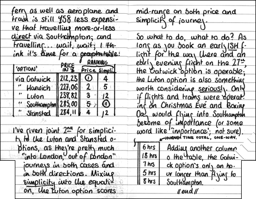
Pages 15 and 16 include a 'cost vs simplicity' table. The circled number ones represent the least costly (column III) and least faffy (column IV) journeys. It's not the prettiest of Moleskine pages but please understand: I was very, very tired and it was close to 01:00... and the table addition on page 16 was drawn/written on Sunday morning, hence its relative neatness.

My findings are that the cheaper options are less direct that the more expensive, as you would expect. I could compromise on saving money and fly into Luton: a train into London and then another train out of London makes that part of the journey relatively painless but it costs a little more, both in the rail fare and time. The Gatwick option is the cheapest—£70 cheaper than flying direct to Southampton—but it would be a job to get onto the correct line out of London for Bournemouth. But, surprisingly, it takes only an hour longer to fly into Gatwick and sachet my way over to the South Western Main Line than it does to fly Flybe to Southampton and then walk the reported “sixty seconds” between the terminal and Southampton Airport Parkway. Gatwick might not be a bad choice after all.

And just so you know, it’s a Stabilo Bionic Worker I use.

Tagged

Transport Map

I haven’t blogged about OpenStreetMap recently. Since moving to the Netherlands, my contributions to the project have slowed right down and since the import of AND data in 2007 (which “finished off” 99% of the Netherlands), I seem to have lost my motivation for all but “armchair mapping“.

But that doesn’t mean I can’t continue to be a part of the project. The main reason I fell in love with OpenStreetMap wasn’t for its ‘default’ style (called Mapnik), but for what one could do with the data. The project and the maps it produces (or helps to produce) are based around a common tagging scheme. You’re perfectly welcome – encouraged even – to take the data and produce a map that shows only the ways, areas or relations with the tags you specify; and filter out or maybe colour differently other tagged data. Maybe that’s not a very good explanation but the idea is that your map or someone else’s specialist map doesn’t have to show the map features that aren’t relevant to its target audience or to its cause.

Here’s a better example. A new style (also known as a rendering) has recently been added to the “most popular” drop-down on the main OpenStreetMap website. Out of the hundreds of renderings out there on the Internet, only four have received the privilege of becoming featured layers on the OpenStreetMap website. The latest is called Transport Map and, as its name suggests, it highlights public transport routes and stops.

Public transport at London Stansted

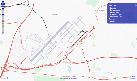
The Stansted Airport area seen through Transport Map. Underlying data © OpenStreetMap.org and its contributors, CC BY-SA; tiles courtesy of Andy Allan.

Transport Map, as shown in the image of the Stansted Airport area above, shows quite clearly the area’s bus routes in red; and at high zoom levels, the line numbers of buses are printed along the route. The style also shows rail-based modes of transport as dashed black lines and as grey lines when underground (such as the tunnel under the runway at Stansted). You can also see the blue menu of the ‘promoted’ map styles at the top-left of the map in the screenshot above.

I really like the modern look of this particular style. The previous heavyweight in the public transport style arena was ÖPNV-Karte but I now find that style a little too …bulky. Do you remember when Apple changed the iTunes logo from thin green lines to thick blue ones?; I’m getting that feeling again. One can see a definite difference between the two maps’ designs if one compares them side-by-side.

Transport Map and ÖPNV-Karte

Central Amsterdam on Transport Map (left) and ÖPNV-Karte (right). Map data © OpenStreetMap.org and its contributors; CC BY-SA. Map tiles © their players.

In my opinion, the more recently designed Transport Map (left) is a lot less gunky and easier to read than ÖPNV-Karte (right). I’m a stickler for clean and minimalistic graphic design, and that’s what I think the Transport Map layer offers. It begins to get more convoluted at lower and lower zoom levels but that’s the case with all map styles.

But going back to talking about including or excluding certain tags from one’s custom style(s) for a second. Note how ferries are rendered in different ways in the screenshot of Amsterdam above. There are two ferries which cross the IJ from behind Centraal Station – ÖPNV-Karte renders ferries with relations purple (like the Fast Flying Ferry which heads northeast towards IJmuiden) but not the GVB ferries; Transport Map on the other hand recognises the tag route=ferry on ways as well as relations, since both companies’ ferries appear the same. All very boring stuff, but I hope it’s a good example of how different tags produce different results – there’s still plenty of work for “armchair mappers” like me to get on with.

→ Blackfriars new design

David Hembrow writes:

The LCC’s proposal looks not entirely different to how some Dutch provision might have looked 30 years ago. There was a lot to like about 30 year old Dutch cycling infrastructure, so this isn’t entirely a bad thing. However, in the second decade of the 21st century, I really think that London should be copying 21st century solutions and not looking quite so far backward.

I haven’t been keeping up with the Blackfriars Bridge news as of late. It seems to have all quietened down in my Google Reader. But I’ve just had a late look at the London Cycling Campaign’s proposals and by god: they almost look European.

Tagged

Fifteen minutes

Commuting by train in the Netherlands is usually no problem. Yesterday, however, Nederlandse Spoorwegen—the state-owned rail operator of the Netherlands—had to delay some of its services. Back in the UK, I wouldn’t even consider writing about delays on the railways: it would be a waste of my time. Everyone[who?] knows the UK suffers from the worst rail delays in Europe[citation needed] and, in my experience at least, encountering delays on the British railway network is anything but unusual. Dutch railways on the other hand: that’s a different story. I wrote the draft of this post on a reasonably-packed (ten people standing in the aisle of a seventy-five-ish-seat-carriage; 113% crowded) intercity naar Enschede; the stoptrein I usually get home from the office was delayed by… well: the announcements said five minutes, but 18:04–17:55 is nine minutes. Anyway, I’m used to a much quieter train—I don’t care for men talking loudly about “the datas [sic] in the clouds”and how “[in] the future, the normal PC will disappear”; people coughing and sneezing on the blue and striped carriage moquette; at least there aren’t any chavs on-board and I haven’t heard a screaming baby sinc– (Out at Hilversum and there’s a shitcake screaming and whaling in a pram on spoor 2.)

Yesterday morning, the stoptrein to Leiden did arrive, fifteen minutes later than scheduled. I arrived at Duivendrecht with perhaps ten minutes to go before work so instead of risking arriving late by walking, I hopped on the Metro—what a foul and disgusting one-stop journey that was. I’ll have to research, but I swear those carriages were from the 70s, complete with an 8-bit ‘hammers’ voice announcer. Then, after running off the train and elbowing everyone London-style, …I fell down a fifteen-step staircase on the way out of the station: where was this sign when I needed it?

I wrote this post over the course of about an hour-and-a-half yesterday evening and, while waiting for a stoptrein south via oo-treɣt oa-fer-veɣht, in front of me was something I don’t think I’ll ever get used to—a DB service to Hannover Hbf, with announcements for its service in no less than three languages. It’s an odd thought seeïng a train to Germany. I think you need to book a seat reservation in advance, but there’s no glass security fencing like at St Pancras International; no customs or passport control to stress over. It’s an alien idea, this ‘free movement between countries’ thing and that is what I don’t think I’ll get used to.

Tagged

“Overweg vrij laten”

A few mornings ago, on the slow bus into Hilversum, I saw an sign which intrigued me at the level crossing between the platforms at Hilversum Sportpark railway station. The flashing traffic sign—two lights on top, two lights below; flashing like those motorway-side FOG signs that always seem to be on when there’s clearly no fog at all—read:

“Overweg vrij laten”

I saw this sign the other day but alas: it was unlit and I took less notice of it. It turns out this sign is lit during rush hour periods, and reads something along the lines of “keep level crossing clear”. Basically, it’s to remind thick drivers not to blindingly follow the car in front onto the level crossing—only to get stuck with nowhere to go, then hit by a train calling at Hilversum Sportpark.

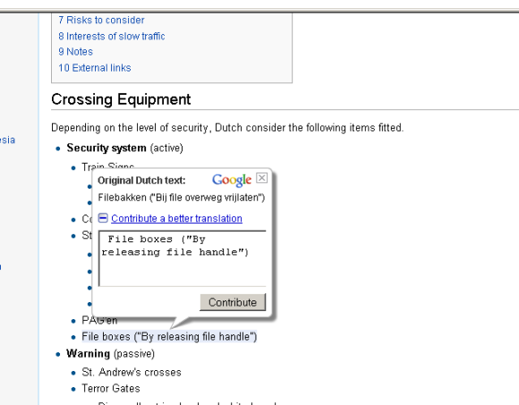
I had to ask a colleague about this sign’s meaning since Google wasn’t much help. It was even less help when I stupidly tried to Google Translate (v.) one result of the search query ‘overweg vrij laten’—the Dutch Wikipedia article on level crossings—into English, since I knew the English article on level crossings wouldn’t have anything at all on vrijs or overwegen. Computer translation, or machine translation, is notorious for failing to take the context of words around a particular word under translation into account. When one Google Translates a website—rather than just a few words or a paragraph—upon hover, small bubbles appear over the translated text, showing the user the original text that was translated but, more interestingly, a “contribute a better translation” link—which when clicked, expands to a simple input field with the English (or rather Dunglish) text ready to be corrected.

A Google Translate'd Wikipedia article, showing Google's "contribute a better translation" bubble

First of all, files (pron. fee-lers) are traffic jams; the singular form of the word files is file, perhaps unsurprisingly. Dutch ‘file’ ≠ English ‘file’—as in a document—though file can also mean a file as in a document in Dutch. I’m only at the first word and the machine translation has already proven itself to be context-insensitive. The lead sentence of the ‘crossing equipment’ section—which should really read something like “…”—reads “depending on the level of security, Dutch consider the following items fitted”. The word order isn’t as bad as in some machine translation cases I’ve seen but it’s wrong, for a start; beveiliging, which the translation engine subsititue with “security”, would be more appropriately translated as “protection”, especially since we’re talking about level crossings. The Dutch noun overwegen—‘level crossings’—has been confused with the Dutch verb overwegen—to consider. The word kunnen (lit. ‘can’, as in “Dutch level crossings can be fitted with the following protections…”) has been ignored completely. Again, the word order towards the end of the sentence is getting raped pretty badly. And this is just one sentence in one of millions of Wikipedia articles. Imagine if the other Wikipedias were simply Google Translate’d ‘copies’ of the English-language site; fuck, that would cause a few arguments on the talk pages …in broken English of course.

Tagged

Trains, ferries and cattle trucks

Yesterday, I had the good fortune of taking Dutch trains to my ferry out of the Netherlands, and the misfortune of suffering at the hands of the shambles we Brits call a rail network.

I arrived at Hollandsche Rading station by bakfiets taxi and I’d purchased my ticket (with extreme ease) at Hilversum Centraal the afternoon before. I’ve discovered there are three types of Dutch train: double-decker, average and Sprinter—in ascending order of shitness. I took an average train the ten-or-so kilometres south to Utrecht, seeing far fewer orange-clad Dutchmen as I was anticipating: for it be/was Koninginnedag. Switching to a double-decker?; no problem, just a change of platform. At Rotterdam, another change of platform and a change of train type: this time to a Sprinter. NS Sprinter services are nippy little buggers; the closest I can relate them to is a trip on a Class 313; anyone reading from north London and Hertfordshire will know that these First Capital Connect trains are shit, dirty, cramped and certainly not worth the £20 one paid to get to London. But, aside from my personal opinion, no problems at all and the price for the journey was €15,20.

On the ferry (actually on the Sprinter to Hoek van Holland) I met a lovely American lady called Ann—she’s currently on a ’round-the-world holiday and having got the train up from Antwerpen the night before, was travelling to Harwich (or ‘Har Wick’ in her words) then onto London. I helped many-an old lady yesterday: one in Utrecht, one in Rotterdam and Ann across the North Sea. She was lovely company, I must say.

At the other end, boarding a train at Harwich International required a half-an-hour wait (though I fully understand that a ‘train meeting a ferry’ should come with a little delay) but no problem beyond my British experience with railways. Manningtree on the other hand was a bit different: the train up from Harwich failed to meet a connection with a train heading towards Ipswich. Five minutes for a connection sounds like a long time …in the Netherlands, where trains run on-time (though actually in the past three weeks, they’ve been running and leaving ahead of time). I was intending to catch a train from Harwich International up to Manningtree, a connection from Manningtree to Ipswich, and then grab a nap on the Ipswich–Cambridge service. No. Kevin instead had to wait an hour for a train to Norwich—though another ferry-goer—Evan of Austin, Texas—was company on the platform, and briefly in the platform-side pub until I realised I only had euros on me. The Norwich train was late by a few minutes, and a few minutes at 21:30 on a Saturday can’t exactly be blamed on overcrowding or whathaveyou. Onwards to Norwich where National Express decided to turn off the lights in my carriage to pocket yet more money for its shareholders (and I guess default on yet another franchise when the going gets tough), and then a ten minute-connection to a train to Cambridge. Via Bury St Edmunds was the original plan but hey.

Oh yeah: just to reiterate. Koninginnedag (Queen’s Day) is a public holiday in the Netherlands. Hollandsche Rading has a population and station no bigger than Foxton, Cambridgeshire: it gets two trains an hour on a public fucking holiday. Foxton gets one train an hour Monday–Friday, you’re lucky if you catch one at the weekend, you’re delusional if you think you can catch one on Bank Holidays and Foxton station has forty-six fewer cycle parking spaces than Hollandsche Rading.

Tagged